


The Fanno Creek Trail will one day have several of its most noticeable gaps in Tigard filled in, thanks to a plan approved last month by the city council.
The Fanno Creek Trail is a regional multi-use path that is envisioned to one day connect the West Hills of Portland at the headwaters of Fanno Creek to the Tualatin River in Durham. So far, however, funding and the political will to turn that vision into reality has not completely materialized, leaving the trail incomplete and patchy. Where the trail exists in Tigard, however, local residents enthusiastically utilize its walking and bicycling path as well as its access to the creek itself.
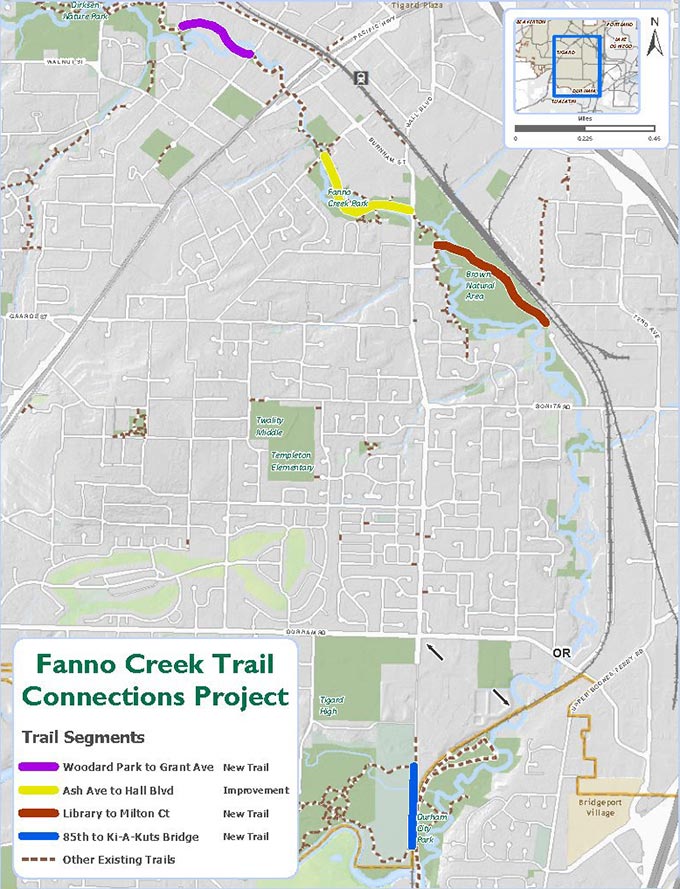
Now, the City of Tigard is poised to construct approximately 1.39 miles of new hard-surfaced pathway built in four specific segments. These will include a new path from Woodard Park to Grant Avenue; the replacement of 1,800 feet of existing path from Ash Avenue to Hall Boulevard; a new path from the Tigard Library to Milton Court; and a new path from Southwest 85th Avenue to the Ki-a-Kuts Bridge, which crosses the Tualatin River just south of Cook Park.
The project will also require construction of two 14-foot-wide bridges over Fanno Creek and additional elevated boardwalks over wetlands, drainage ways and natural areas.
“It’s an important link for Washington County,” said Tigard Engineering Project Coordinator Carla Staedter. “It connects five different cities, and there are in excess of 200,000 uses per year. The trail is currently missing four segments, and this will complete one of those segments.”
Much of the funding for the project will come from state and federal grants, making this a much easier decision for the council.
“This has been a long time coming,” Councilor Liz Newton said. “This is something I hear about from the community, which is ‘When is this going to happen?’ So good job for getting this done.”
There is no timeline for construction of the trail extension just yet, and formal approval of the project was made more complex due to the different types of property it will traverse.
The council approved a comprehensive plan amendment to remove protection from a combined total of 1.13 acres of locally significant wetlands and City-regulated vegetated corridors. Then, because small portions of the trail would run through residential property, a conditional use permit is required. Finally, a sensitive lands review is needed to gauge the impacts of the trail on vegetated corridors, a Federal Emergency Management Agency floodway and steep slopes.
The Woodard Park to Grant Avenue connection is the most desirable for the city because the existing trail abruptly ends at Johnson Street, which has no sidewalk.
“This has been a very popular segment of the trail,” Staedter said.
The Ash Avenue to Hall Boulevard extension, meanwhile, will be slightly narrower than the rest, while the new segment running from the library to Milton Court will feature a bridge over Fanno Creek as it cuts through several open spaces.
Finally, the stretch of trail running from S.W. 85th Ave. to the Ki-a-Kuts Bridge is relatively distant from the others. It will run from the Durham treatment plant along railroad tracks and meet up with the existing trail under the rail bridge and then extend to the Ki-a-Kuts bridge on the Tualatin River. This section, Staedter said, will eventually help divert commuter bicycle traffic from Cook Park and remove some of the current congestion from that popular location.
“It’s a wider trail and a much better route for commuter traffic,” she said, “It’s much better for cyclists.”


