


Studying topographic maps is not a substitute for walking on the land, as King City officials and planners learned on a recent boots-on-the-ground field trip through the city’s urban growth boundary area, located between the Edgewater development, Beef Bend Road, Roy Rogers Road and the Tualatin River.
A group of local residents opposed to a proposed plan to extend Fischer Road from Edgewater west through the UGB area in the future Kingston Terrace set up three walking tours in parts of the 528-acre site in June for city officials and other interested parties.
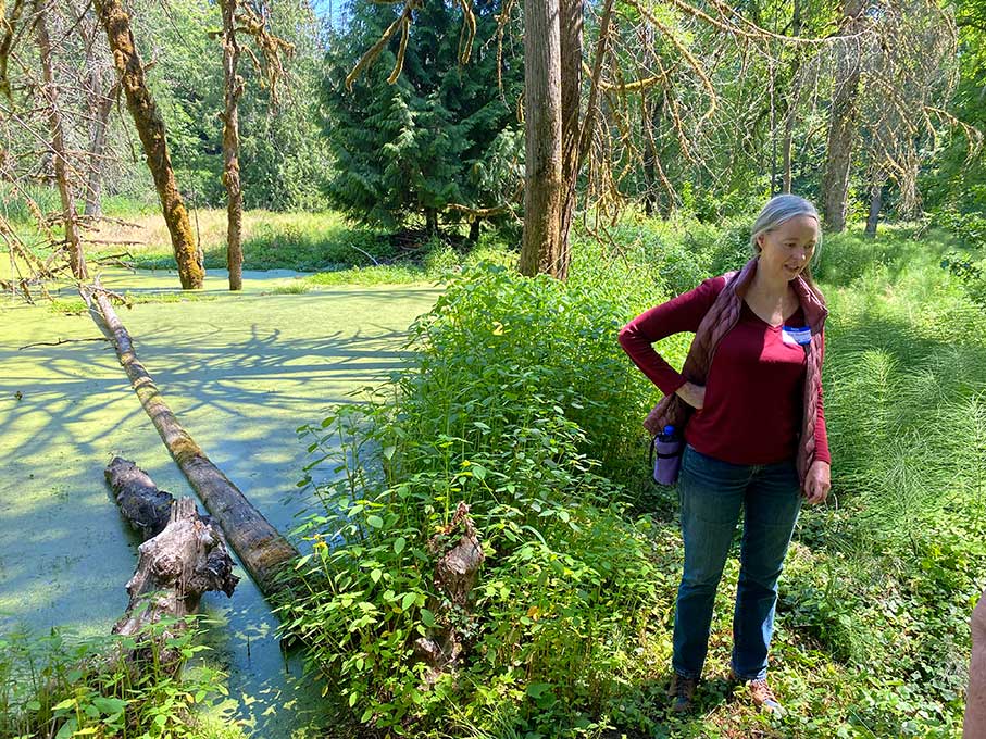
On June 24 about two dozen people, including Mayor Ken Gibson, City Manager Mike Weston, several members of the City Council and Planning Commission, planning consultants and residents of Edgewater and the UGB area, met at the property of Gregg Russell in Rivermeade, a 58-parcel, large-lot community created in 1948 on the Tualatin River.
“We want to show you the ecological and financial impacts of Fischer going through and the alternatives,” Russell said. “Google maps just don’t do it justice.”
From Russell’s property, the group walked through part of a 12.82-acre site where Carla Bankston lives on land that belonged to her mother Charlene, who turned it into a conservation easement with the Columbia Land Trust to protect it from future development.
Carla Bankston told the group as it ventured partway down a canyon in the middle of a forest, “This could be the site of old growth timber in 200 years.”
Mike Meyer, who lives nearby, exclaimed, “What a gem this area is. But noise reverberates in canyons, and if you have 8,000 to 10,000 vehicles passing through here every day, it will be thunderous. When you come down here now, it is like being in paradise.”
Gibson asked if the future development could include resolving some of the existing environmental issues.
“There is some benefit to development if done the right way,” Gibson said. “I am committed to do it the right way… But it is a daunting task.”
Ashley Short, an environmental attorney with the Tualatin Riverkeepers, discussed the high cost of legal and financial remedies for existing environmental damage and stressed that King City would incur the least expense by punching an east-west connector road through the UGB area “as far north as possible, closest to Beef Bend Road.”
She added, “The Tualatin Riverkeepers are not against growth, we just want environmental protections with it.”
Gibson said, “We need to team up to benefit King City and the landowners in this area and find a good, healthy way of looking at it,” and Short added, “I think we agree with your goal.”
There are about 330 acres of land suitable for development in the UGB area, where the second stop on the tour was the Meyer family property.
Mike Meyer’s great-great-grandfather originally purchased 40 acres along the river, where generations of the family have lived ever since. But the property has been decimated by run-off from development above it on Bull Mountain.

Years ago, Meyer put in a small culvert, which was eventually replaced by a 40-inch one, and he is now adding a second 40-inch culvert to handle the ever-increasing water flow.
He led the group to the “Meyer Grand Canyon” that when he was a child was a small creek running into the river but has now turned into a canyon at least 20 feet deep and growing due to the torrents of water rushing through every rainy season.
“Pretty much everyone beyond 150th wants to sell (to developers), but we don’t want a cut-through road from 99W to Roy Rogers Road,” Meyer explained.
The last stop on the tour was closer to Roy Rogers Road, where Michael O’Halloran’s dad purchased 42 acres along Beef Bend Road 60 years ago, “and we’ve been farming ever since.”
He led the group to the edge of a cliff where the Tualatin River had eroded all the soil beyond it, and part of a fence dangled in mid-air where it used to cross what is now a deep canyon.
This case of erosion can’t be blamed on run-off from development, and O’Halloran explained that when the river runs high one month out of the year, it washes away the soil, a process aided by all the gopher holes on the land that “act like water pipes to accelerate the process.”
The next step in the Kingston Terrace Master Plan process is to analyze alternate east/west street connections. This will build on the work of the Transportation System Plan and consider factors like vehicle traffic, pedestrian and bicycle access, neighborhood impacts, environmental impacts and cost.
For more information, visit the city’s website at www.ci.king-city.or.us.
And just to make sure city officials know where many residents stand on the issue, front yards across King City are dotted with signs that read, “STOP Fischer Road Extension!!”

")


